SOUTH CENTRAL OZARK COUNCIL OF GOVERNMENTS
  • Home
  • About Us
    • Contact Us
    • SCOCOG Boards and Associate Members
    • Current and Past Projects
    • Employment Opportunities
  • Programs
    • Household Water Well Program
    • Economic Development Planning
    • Delta Regional Authority (DRA)
    • Community Development Block Grant (CDBG)
    • Hazard Mitigation Planning
    • Regional Homeland Security Oversight Committee (RHSOC)
    • Solid Waste
    • Transportation (TAC)
    • Community Planning
    • Other Projects >
      • Municipal Stormwater Management Planning >
        • Stormwater Planning - Risk Assessment Maps
        • Stomwater Planning - Infrastructure Maps
        • Stormwater Planning - Culvert Condition Maps
  • Notices and Bids
    • Public Notices
    • Bid Documents
    • Upcoming Events in the Area
  • Publications and Reports
    • SCOCOG Reports and Documents
    • Comprehensive Economic Development Strategy
  • Partners
  • Member Communities
  • Chambers of Commerce
  • Title VI Plan

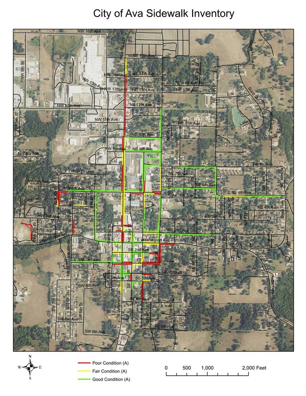
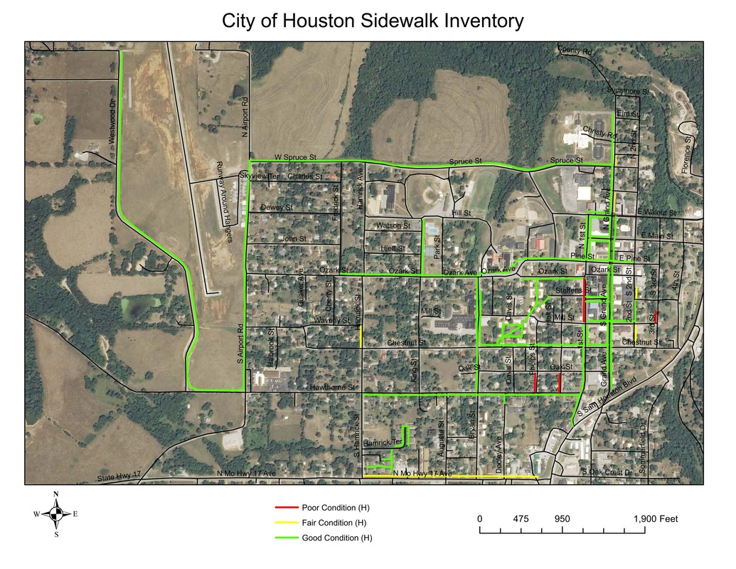
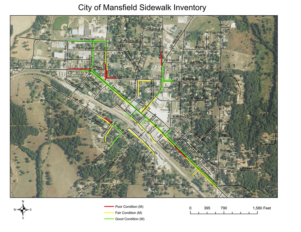
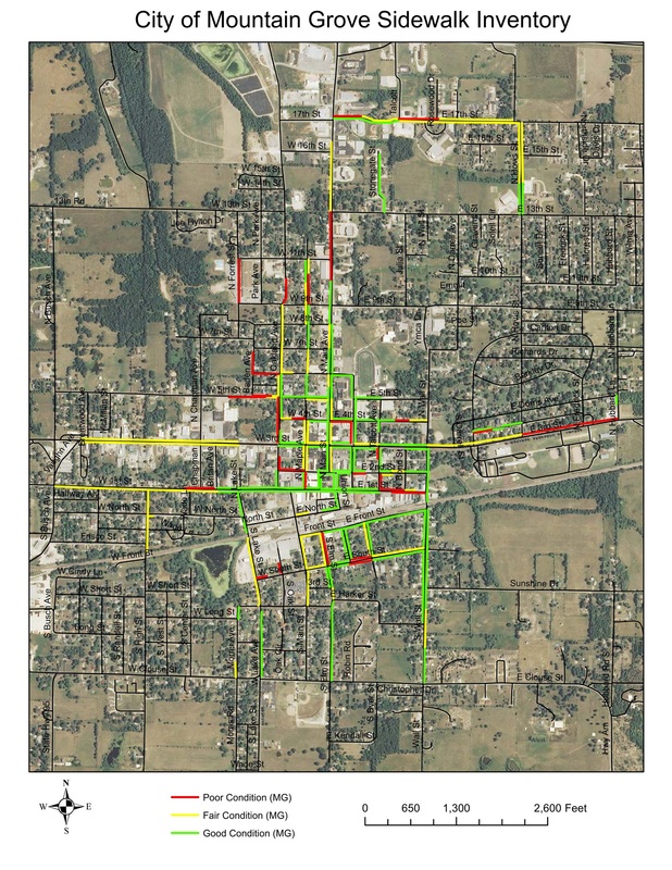
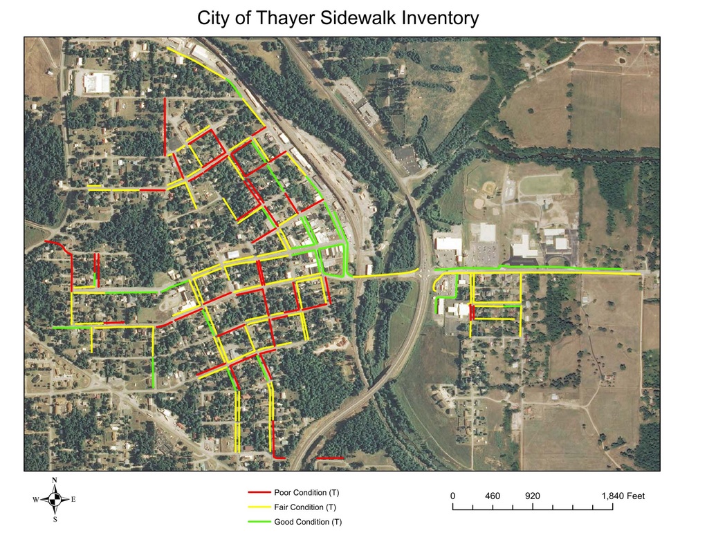
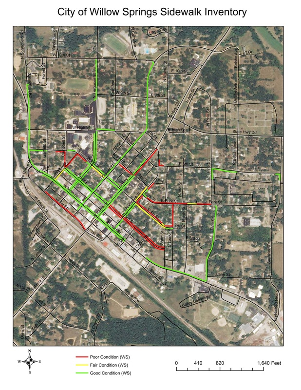
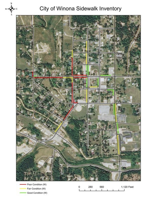
2012 Sidewalk Conditions Maps

The sidewalk ratings were labeled "Good", "Fair", and "Poor" based upon criteria such as slope, cracks, upheaval of sections, and overall walkability. The ratings were applied with thought of how easy would the average pedestrian be able to traverse the particular stretch of sidewalk. Once initial field surveys were completed, the information was brought back to our office where it was drawn over an aerial image to give an overall sidewalk map of the each city.

The overarching purpose of this inventory was to make cities aware of the condition of the sidewalks in their community and to assist in applying for improvement grants from federal and state agencies. The maps can also be used as a tool in preparing a new or updating an old Sidewalk Plan for the community. If you would like more information about developing a sidewalk plan for your community please give Cody Dalton a call at (417) 256-4226 or email at cdalton@scocog.org


Sidewalk Inventory Maps in PDF:

Ava
File Size: 437 kb
File Type: pdf
Download File

Cabool
File Size: 276 kb
File Type: pdf
Download File

Houston
File Size: 263 kb
File Type: pdf
Download File

Licking
File Size: 290 kb
File Type: pdf
Download File

Mansfield
File Size: 271 kb
File Type: pdf
Download File

Mtn. Grove
File Size: 453 kb
File Type: pdf
Download File

Mtn. View
File Size: 247 kb
File Type: pdf
Download File

Thayer
File Size: 277 kb
File Type: pdf
Download File

Willow Springs
File Size: 365 kb
File Type: pdf
Download File

Winona
File Size: 291 kb
File Type: pdf
Download File

  • Home
  • About Us
    • Contact Us
    • SCOCOG Boards and Associate Members
    • Current and Past Projects
    • Employment Opportunities
  • Programs
    • Household Water Well Program
    • Economic Development Planning
    • Delta Regional Authority (DRA)
    • Community Development Block Grant (CDBG)
    • Hazard Mitigation Planning
    • Regional Homeland Security Oversight Committee (RHSOC)
    • Solid Waste
    • Transportation (TAC)
    • Community Planning
    • Other Projects >
      • Municipal Stormwater Management Planning >
        • Stormwater Planning - Risk Assessment Maps
        • Stomwater Planning - Infrastructure Maps
        • Stormwater Planning - Culvert Condition Maps
  • Notices and Bids
    • Public Notices
    • Bid Documents
    • Upcoming Events in the Area
  • Publications and Reports
    • SCOCOG Reports and Documents
    • Comprehensive Economic Development Strategy
  • Partners
  • Member Communities
  • Chambers of Commerce
  • Title VI Plan